Yes, Virginia! 9/21/09
As I write this Sam and Sallie are a day’s hike south of Pearisburg, Virginia a town of about 2700-folks and the home of Andrew Johnston, the 17th President of the U.S. Our southbound duo has completed 1552-miles and have just 626-miles to go. They are right on schedule to finish at Springer Mountain, Georgia the last weekend in October.
Sam’s and Sallie’s recent trail experiences have included flocks of wild turkey, whitetail deer, raccoon, and the obligatory squirrels and chipmunks. Probably the worst encounter so far and certainly the most painful was a couple of weeks ago when our hikers got a little too close to a trailside yellow jacket nest. Sallie took several direct hits while Sam collected at least three or four pretty painful stings. With no ice or sting swabs available, they had to just “tough it out.” Sam said it sure did feel good when it stopped hurting. A day or so later, they came upon another yellow jacket nest literally “on” the trail. This one a bear had raided and dug it up stirring up a maelstrom of winged warriors looking for revenge. Sam and Sallie gave them plenty of room by skirting the area off the trail.
The Appalachian Trail south of the Shenandoah Park has numerous mountain crossings in the 4000-foot range and then, as it leaves the Blue Ridge, it generally hangs out in the 1500 to 2000-foot elevation for miles and miles. The elevations are broken only by gentle descents into the valleys which lay in the 1000-foot range. There have been no dramatic changes in altitude for the past couple of weeks, therefore, not much change in weather or scenery.
One of the more interesting points along the trail the past few days has been McAfee Knob, long famous in AT publications as one of the more photogenic spots on the trail with plenty of jutting rocks on the edge of the mountain on which to pose while a companion takes a photo. By the way, speaking of photos, Sam was heard to say that Sallie was doing a solo thru-hike and he was tagging along as her photographer.
The weather has been a bit more pleasant the past couple of weeks. A few warm days have made work out of some of the ascents, but for the most part a breeze has been moving the air and cooling the trekkers. Night time temps have fallen into the upper 50’s some evenings making sleep even better.
Sam and Sallie are averaging 3-miles per hour and most days put in five to six hours. Sam has found that racking up more than18-miles requires some payback the next day. Therefore, they are taking it easy, if you can carry a 35-pound pack 18-miles up and down mountains and call that “easy.”
Near Pearisburg, Sam and Sallie crossed the New River, one of the oldest and most interesting rivers in North America. Contrarily named, the New River is actually one of the oldest rivers on our continent. It is the only southern river that flows mostly north and is the only river that completely traverses the entire Appalachian range. After crossing the New, the trail begins to ascend to the 5000-foot level where it will pretty much remain for the rest of Virginia. This is the first time since New Hampshire that the AT has been this high. It’s giving the pair of hikers a respite from the heat of the valleys below.
A number of you have asked how do you follow the AT for 2178-miles and not get lost. Well the trail is marked by white blazes painted on trees and rocks every few hundred feet or so. Changes in direction are denoted by two blazes. The trail maintenance groups try to keep the blazes within sight of each other, repainting them frequently. Still, in a driving rain storm or the fading light of dusk, it’s easy to miss a blaze and get off the trail. There are many, many side trails that look the same except they are marked by blue blazes instead of white. Another handy resource is the official guidebook which not only contains a detailed narrative description of the trail, but highly detailed maps of the area. A GPS is handy, but most thru-hikers opt out on carrying one due to the added weight and battery requirements.
Sam and Sallie are receiving regular shipments of staples and treats from home. Sam’s mother-in-law got in on the action this past week, sending a “care package” from Oxford, Mississippi. Sallie is maintaining her weight at 65-pounds and has suffered no serious foot problems since New Hampshire. Sam’s weight is a stable 195-pounds with his daily intake between 9,000 and 10,000 calories.
Sam is now on his third pair of Keen hiking shoes, having received a replacement pair just this week. The Keen shoes may seem a bit fragile to some, with him having gone through three pair in 1500-miles. They do really take a beating day-in and day-out, wet or dry, never getting a rest day,. Rocks seem to take the biggest toll on footwear. Indeed, there are millions of jagged, sharp rocks on the trail. Consider though, the alternative to the Keen shoes or similar lightweight expedition models: they weigh just a couple of ounces compared to the old standard leather hiking boot which may weigh upwards of 3-pounds. Now which shoe would you prefer to be walking two thousand miles in? Kinda’ puts a new meaning to the phrase “walk a mile in my shoes” doesn’t it?
We’re pleased to report that other equipment issues have been taken care of by local outfitters or the manufacturers in every case. Keen has replaced the failed shoes at no cost. Leki replaced the broken hiking poles and Platypus replaced the hydration system through an outfitter. There’s been nothing but good to report about the manufacturers and how they stand behind their equipment.
While staying in Daleville, Virginia, Sam visited the local outfitter and was invited to attend a “ZZ Top” concert in nearby Roanoke. Not being of the same generation as “ZZ Top” one had to wonder how Sam liked their music. He reported that he had a great time and had not realized it, but he actually had a “ZZ Top” starter kit beard. LOL
Damascus, Virginia is in the sights now as Sam and Sallie take up the trail for their last push in the longest state on the trail. Sam’s mom and I plan to rendezvous with the pair somewhere around Damascus near the first weekend in October. We haven’t laid eyes on the boy since early May and Peggy’s getting pretty anxious about the trip. We plan on feeding them and giving them a good place to bed down each evening for a while. Sallie isn’t allowed in Smoky Mountain National Park, so we’ll be “sitting” her for a few days while Sam does some slack packing through the park.
Sam and Sallie thoroughly enjoy your posts, emails, and comments. Keep them coming to mclemoresam@yahoo.com. You can also read the complete adventure at http://samboat.blogspot.com/. Until next time remember:
Yard by Yard, Life is Hard!
Inch by Inch, Life’s a Cinch!
Sam’s and Sallie’s recent trail experiences have included flocks of wild turkey, whitetail deer, raccoon, and the obligatory squirrels and chipmunks. Probably the worst encounter so far and certainly the most painful was a couple of weeks ago when our hikers got a little too close to a trailside yellow jacket nest. Sallie took several direct hits while Sam collected at least three or four pretty painful stings. With no ice or sting swabs available, they had to just “tough it out.” Sam said it sure did feel good when it stopped hurting. A day or so later, they came upon another yellow jacket nest literally “on” the trail. This one a bear had raided and dug it up stirring up a maelstrom of winged warriors looking for revenge. Sam and Sallie gave them plenty of room by skirting the area off the trail.
The Appalachian Trail south of the Shenandoah Park has numerous mountain crossings in the 4000-foot range and then, as it leaves the Blue Ridge, it generally hangs out in the 1500 to 2000-foot elevation for miles and miles. The elevations are broken only by gentle descents into the valleys which lay in the 1000-foot range. There have been no dramatic changes in altitude for the past couple of weeks, therefore, not much change in weather or scenery.
One of the more interesting points along the trail the past few days has been McAfee Knob, long famous in AT publications as one of the more photogenic spots on the trail with plenty of jutting rocks on the edge of the mountain on which to pose while a companion takes a photo. By the way, speaking of photos, Sam was heard to say that Sallie was doing a solo thru-hike and he was tagging along as her photographer.
The weather has been a bit more pleasant the past couple of weeks. A few warm days have made work out of some of the ascents, but for the most part a breeze has been moving the air and cooling the trekkers. Night time temps have fallen into the upper 50’s some evenings making sleep even better.
Sam and Sallie are averaging 3-miles per hour and most days put in five to six hours. Sam has found that racking up more than18-miles requires some payback the next day. Therefore, they are taking it easy, if you can carry a 35-pound pack 18-miles up and down mountains and call that “easy.”
Near Pearisburg, Sam and Sallie crossed the New River, one of the oldest and most interesting rivers in North America. Contrarily named, the New River is actually one of the oldest rivers on our continent. It is the only southern river that flows mostly north and is the only river that completely traverses the entire Appalachian range. After crossing the New, the trail begins to ascend to the 5000-foot level where it will pretty much remain for the rest of Virginia. This is the first time since New Hampshire that the AT has been this high. It’s giving the pair of hikers a respite from the heat of the valleys below.
A number of you have asked how do you follow the AT for 2178-miles and not get lost. Well the trail is marked by white blazes painted on trees and rocks every few hundred feet or so. Changes in direction are denoted by two blazes. The trail maintenance groups try to keep the blazes within sight of each other, repainting them frequently. Still, in a driving rain storm or the fading light of dusk, it’s easy to miss a blaze and get off the trail. There are many, many side trails that look the same except they are marked by blue blazes instead of white. Another handy resource is the official guidebook which not only contains a detailed narrative description of the trail, but highly detailed maps of the area. A GPS is handy, but most thru-hikers opt out on carrying one due to the added weight and battery requirements.
Sam and Sallie are receiving regular shipments of staples and treats from home. Sam’s mother-in-law got in on the action this past week, sending a “care package” from Oxford, Mississippi. Sallie is maintaining her weight at 65-pounds and has suffered no serious foot problems since New Hampshire. Sam’s weight is a stable 195-pounds with his daily intake between 9,000 and 10,000 calories.
Sam is now on his third pair of Keen hiking shoes, having received a replacement pair just this week. The Keen shoes may seem a bit fragile to some, with him having gone through three pair in 1500-miles. They do really take a beating day-in and day-out, wet or dry, never getting a rest day,. Rocks seem to take the biggest toll on footwear. Indeed, there are millions of jagged, sharp rocks on the trail. Consider though, the alternative to the Keen shoes or similar lightweight expedition models: they weigh just a couple of ounces compared to the old standard leather hiking boot which may weigh upwards of 3-pounds. Now which shoe would you prefer to be walking two thousand miles in? Kinda’ puts a new meaning to the phrase “walk a mile in my shoes” doesn’t it?
We’re pleased to report that other equipment issues have been taken care of by local outfitters or the manufacturers in every case. Keen has replaced the failed shoes at no cost. Leki replaced the broken hiking poles and Platypus replaced the hydration system through an outfitter. There’s been nothing but good to report about the manufacturers and how they stand behind their equipment.
While staying in Daleville, Virginia, Sam visited the local outfitter and was invited to attend a “ZZ Top” concert in nearby Roanoke. Not being of the same generation as “ZZ Top” one had to wonder how Sam liked their music. He reported that he had a great time and had not realized it, but he actually had a “ZZ Top” starter kit beard. LOL
Damascus, Virginia is in the sights now as Sam and Sallie take up the trail for their last push in the longest state on the trail. Sam’s mom and I plan to rendezvous with the pair somewhere around Damascus near the first weekend in October. We haven’t laid eyes on the boy since early May and Peggy’s getting pretty anxious about the trip. We plan on feeding them and giving them a good place to bed down each evening for a while. Sallie isn’t allowed in Smoky Mountain National Park, so we’ll be “sitting” her for a few days while Sam does some slack packing through the park.
Sam and Sallie thoroughly enjoy your posts, emails, and comments. Keep them coming to mclemoresam@yahoo.com. You can also read the complete adventure at http://samboat.blogspot.com/. Until next time remember:
Yard by Yard, Life is Hard!
Inch by Inch, Life’s a Cinch!
Sam on the AT - Oh Shenandoah!
Sam and Sallie have spent the past several days on the Appalachian Trail in the Shenandoah National Park. The Park includes many of the higher elevations that overlook the beautiful Shenandoah Valley of Virginia. The AT in the park pretty much follows the path of the famous Skyline Drive at the northern end of the Blue Ridge Parkway. Being just a short drive from Washington, D.C. and other densely populated areas on the East coast, the park sees literally millions of visitors each year. The area is flush with wildlife and most weekends bring out hundreds of hikers walking the over 400-miles of various trails in the park.
Sam and Sallie are just over 840-miles from the southern terminus of the AT Springer Mountain, Georgia. They are averaging just under 20-miles per day – a fairly good pace and are on schedule to complete this 2178-mile epic journey around the last week in October.
The equipment is holding up well considering what it’s had to endure in the past 1300-miles or so. The Keen Shellrock Mid shoes are holding up well, although they can use a new pair of insoles. The Platypus hydration system has developed a leak that has rendered it inoperable until the next outfitter’s store. The Platypus consists of a heavy duty plastic bladder or reservoir and vinyl hose with a special valve on the end. The reservoir is filled with water and stored in a special pocket in the back pack. The hose clips to the shoulder strap of your rig making water available without having to stop or open a bottle. All other equipment is standing the test of the trail. The hammock or sleep bivy has performed exceptionally well as well as the backpack system. Sam’s self-designed and fabricated poncho and rain tarp have been the talk of the trail. This might be something to think about making and marketing later.
Sallie is Sam’s friend for life. This journey has bonded their relationship. Robert Ruark writing in the Old Man and the Boy said that every man deserves to own one good dog in his life. Well, Sallie has to be that one good dog. Though she’s had some pretty warm days lately, Sam has refrained from shearing her long coat. She’ll be needing it very soon as the pair heads into the highest elevations of the trail as it traverses North Carolina and Tennessee.
The weather is decidedly changing to fall in the Virginia highlands. Daytime temps this week have been in the upper 70’s while the nights are cooling down with some spots experiencing the upper 40’s for the first time since spring. Sam and Sallie are hiking between 1500 and 2500-feet following the crest of the Blue Ridge Mountains and the weather can be good bit cooler higher up than down in the valley.
Wildlife sightings have picked up in the Shenandoah. Sam reports seeing black bear almost every day now. He’s spotted quite a few deer both the Virginian Blacktail and the Eastern Whitetail. Just the other day right at dusk, he came upon a very large bodied whitetail buck with antlers in velvet. He counted 12-points as he was snapping a photo of the animal no more than 20-feet away. Speaking of close encounters, earlier in the week, Sam heard a commotion just a few feet off of the trail. He turned just in time to see a bear cub scuttle up a tree less than a couple of yards from him. With Sallie on her leash (park regulations) they immediately began to back up the trail when, suddenly another cub spooked and began to run through the brush from a nearby side trail. Sam figured that this was a fairly precarious situation and it certainly held the prospect for getting worse if mamma bear showed up. Well guess what? Mamma bear did appear, but she was about 30-yards down the trail past where the first cub climbed the tree. She made a low grunting sound and both cubs took out to her. She turned and went back down the trail from the direction she had approached. Crisis averted! Several other times Sam and Sallie have encountered bear, each time the bears change course when they spot Sal. Other wildlife is in abundance in the park, squirrels and chipmunks by the “gazillions,” mice, and raccoons. Wild turkey feed across the meadows that the trail cuts. Sam was able to capture several different owls in photos while they napped on limbs during the day.
For the Appalachian Trail, Virginia has more miles than any other state with 533. Sam and Sallie are about 120-miles into it now. With roughly 4-weeks of Virginia ahead, it’s easy to understand why so many hikers drop out in this state. It seems like it will never end. As the trail heads southwest to meet up with North Carolina and Tennessee, the mountains begin to get higher with many elevations reaching the upper four thousand foot mark. Of course, if you climb a 4800-foot mountain, you’ve also got to descend that 4800-feet or at least a goodly part of it. That is where the work in backpacking the AT comes in. A 15 to 20-mile day can possibly see an elevation gain of seven to eight thousand feet in that distance. That is literally like climbing up a mile and a half. Remember also that Sam and Sallie each carry their own backpacks. Sam weighs anywhere from 32 to 38-pounds on this section of the trail while Sallie carries around 10-pounds most days.
So long for now. More updates next week as communication with the trekking pair gets a little easier. Don’t forget to check Sam’s personal blog at http://sambomc.blogspot.com/ . He’s updating it more often now that he has a little better web access. The blog with all of these accounts of Sam and Sallie can be found at http://samboat.blogspot.com/. Send Sam an Sallie a note of encouragement at mclemoresam@yahoo.com. He really appreciates all of the cards and letters he’s been receiving from the folk’s back home.
"Inch by Inch Life's a Cinch, Yard by Yard, Life is Hard!"
Sam and Sallie are just over 840-miles from the southern terminus of the AT Springer Mountain, Georgia. They are averaging just under 20-miles per day – a fairly good pace and are on schedule to complete this 2178-mile epic journey around the last week in October.
The equipment is holding up well considering what it’s had to endure in the past 1300-miles or so. The Keen Shellrock Mid shoes are holding up well, although they can use a new pair of insoles. The Platypus hydration system has developed a leak that has rendered it inoperable until the next outfitter’s store. The Platypus consists of a heavy duty plastic bladder or reservoir and vinyl hose with a special valve on the end. The reservoir is filled with water and stored in a special pocket in the back pack. The hose clips to the shoulder strap of your rig making water available without having to stop or open a bottle. All other equipment is standing the test of the trail. The hammock or sleep bivy has performed exceptionally well as well as the backpack system. Sam’s self-designed and fabricated poncho and rain tarp have been the talk of the trail. This might be something to think about making and marketing later.
Sallie is Sam’s friend for life. This journey has bonded their relationship. Robert Ruark writing in the Old Man and the Boy said that every man deserves to own one good dog in his life. Well, Sallie has to be that one good dog. Though she’s had some pretty warm days lately, Sam has refrained from shearing her long coat. She’ll be needing it very soon as the pair heads into the highest elevations of the trail as it traverses North Carolina and Tennessee.
The weather is decidedly changing to fall in the Virginia highlands. Daytime temps this week have been in the upper 70’s while the nights are cooling down with some spots experiencing the upper 40’s for the first time since spring. Sam and Sallie are hiking between 1500 and 2500-feet following the crest of the Blue Ridge Mountains and the weather can be good bit cooler higher up than down in the valley.
Wildlife sightings have picked up in the Shenandoah. Sam reports seeing black bear almost every day now. He’s spotted quite a few deer both the Virginian Blacktail and the Eastern Whitetail. Just the other day right at dusk, he came upon a very large bodied whitetail buck with antlers in velvet. He counted 12-points as he was snapping a photo of the animal no more than 20-feet away. Speaking of close encounters, earlier in the week, Sam heard a commotion just a few feet off of the trail. He turned just in time to see a bear cub scuttle up a tree less than a couple of yards from him. With Sallie on her leash (park regulations) they immediately began to back up the trail when, suddenly another cub spooked and began to run through the brush from a nearby side trail. Sam figured that this was a fairly precarious situation and it certainly held the prospect for getting worse if mamma bear showed up. Well guess what? Mamma bear did appear, but she was about 30-yards down the trail past where the first cub climbed the tree. She made a low grunting sound and both cubs took out to her. She turned and went back down the trail from the direction she had approached. Crisis averted! Several other times Sam and Sallie have encountered bear, each time the bears change course when they spot Sal. Other wildlife is in abundance in the park, squirrels and chipmunks by the “gazillions,” mice, and raccoons. Wild turkey feed across the meadows that the trail cuts. Sam was able to capture several different owls in photos while they napped on limbs during the day.
For the Appalachian Trail, Virginia has more miles than any other state with 533. Sam and Sallie are about 120-miles into it now. With roughly 4-weeks of Virginia ahead, it’s easy to understand why so many hikers drop out in this state. It seems like it will never end. As the trail heads southwest to meet up with North Carolina and Tennessee, the mountains begin to get higher with many elevations reaching the upper four thousand foot mark. Of course, if you climb a 4800-foot mountain, you’ve also got to descend that 4800-feet or at least a goodly part of it. That is where the work in backpacking the AT comes in. A 15 to 20-mile day can possibly see an elevation gain of seven to eight thousand feet in that distance. That is literally like climbing up a mile and a half. Remember also that Sam and Sallie each carry their own backpacks. Sam weighs anywhere from 32 to 38-pounds on this section of the trail while Sallie carries around 10-pounds most days.
So long for now. More updates next week as communication with the trekking pair gets a little easier. Don’t forget to check Sam’s personal blog at http://sambomc.blogspot.com/ . He’s updating it more often now that he has a little better web access. The blog with all of these accounts of Sam and Sallie can be found at http://samboat.blogspot.com/. Send Sam an Sallie a note of encouragement at mclemoresam@yahoo.com. He really appreciates all of the cards and letters he’s been receiving from the folk’s back home.
"Inch by Inch Life's a Cinch, Yard by Yard, Life is Hard!"
Sam's Blog Updates
Sam has recently updated his personal blog. Check it out at http://sambomc.blogspot.com/2009/08/appalachian-trail-conservancy-harpers.html
Southbound and Down! 8/18/09
Sam on the AT – Southbound and Down! 8/18/09
Sam and Sallie turned their faces to the south last week and despite a torrential rain storm or two and some unseasonably hot weather, they racked up 130-miles in seven days, an average of 17+miles per day.
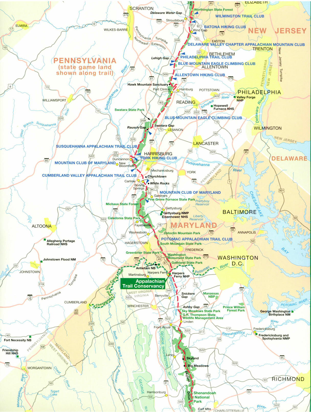
Sunday, August 9th, fresh from a good night’s rest, having had a visit from his sister Meredith the day before, Sam put Duncannon, Pennsylvania behind him and headed to Harper’s Ferry, West Virginia about 136-miles down trail.
Harper’s Ferry and the nearby Appalachian Trail is one of the most historical sections that hikers ply. After crossing the Susquehanna River the AT turns southward leading over Sharps Mountain where the rocks are Pocono Formation sandstone and siltstone. From there, it plies the spine of Blue Mountain until it drops into the Cumberland Valley. There it seems a love/hate relationship develops between the thru-hiker and the valley. This arises from the fact that the hiker has left the boulder strewn higher trails and has descended into a flat expanse of low country. Down here it can be oppressively hot and shade is at a premium, but it’s actually a fairly pleasant area for a residential community. The ATC has for years been trying to relocate the Trail to a more remote ridge-top route. The next big climb, South Mountain can be viewed for miles before the ascent. Finally back in the woods and shade, you are in precipitous country here with sharp ridges and sheer cliffs. The surrounding ridges are littered with the remains of the old iron industry. There are reminders all the way along to the Maryland border of the industry that thrived here from the Revolutionary War up through the War of Northern Aggression (Civil War).
As the AT descends back down to Caledonia Gap, history hits you slap in the face. It was through this gap in the mountains that Robert E. Lee led his army on their way to Gettysburg in late June of 1863. It was also near here that John Brown carried out raids against government agents in 1859. Just south of the AT stands Sharpsburg, Maryland, where in 1862, Generals Lee and McClellan fought the bloodiest battle in the War (Antietam).
The AT cuts the Mason-Dixon Line and the hiker is finally in the “True South” at the Pennsylvania – Maryland border. This section of the trail is one of many ghosts. The story of these hills is written in their blood. The very same gaps, mountains, and settlements on the AT maps of today, appeared on the maps of the French during the French and Indian War. Harpers Ferry is among the most contested spots in American history.
Sam and Sallie made it through Turner’s Gap on the AT, on the very same trail that British General Braddock and young officer George Washington traveled with their army to engage the French. After Braddock was killed in battle, Washington and his weary troops stopped while retreating to rest at the South Mountain Tavern which stands today. This part of the trail became the National Road to the West over which some many settlers moved west. Abe Lincoln stayed at the South Mountain Tavern on his way to Congress. This is also Stonewall Jackson country, having seen the General and his troops harass and bloody the nose of the Union’s finest on several occasions during the early months of the War.
Interestingly, the AT follows a stone wall for a ways here. The wall denotes a boundary that was surveyed by a 17-year old George Washington. The oldest national monument to George Washington stands nearby. The stone tower was built in 1827, almost 75-years prior to the “famous” monument in D.C.
Sam’s shoes are holding up well on this part of the trail. His only gear problem at the moment is a broken hiking staff. The fine folks at Leki, the manufacturer, said “no problem” and dropped another set in the mail right away. Sam is carrying about 40-pounds in his pack now. This includes about 16-pounds of food – enough for four to five days. The re-supply stops are more frequent here since the wilderness is somewhat “thinner” shall we say.
Sallie’s doing great! She is so devoted to Sam. Her weight is steady now at around 60-pounds. She continues to carry her own rations and gear. More of a concern now that the temps are getting up into the nineties is Sallie’s long, thick coat of jet-black hair or fur. Sam’s begun looking for a groomer to shear some of that hot coat from Sal so she’ll have a cooler time of it.
Sunday, the pair made it into Harpers Ferry and happened upon another thru-hiker who resides there. In typical “trail angel” manner, he invited Sam and Sallie to stay at his place. Wow, a real bed and home cooked meal or two! He even drove Sam to the Post Office to pick up his mail drop and then to the market for a few food items. Monday afternoon found Sam, friend, and Sallie all out in the Potomac River on rafts and tubes escaping the heat.
Tuesday morning it’s back to reality and the trail. The next big supply stop will be Front Royal, Virginia at the head of the Shenandoah Valley and the start of the Blue Ridge Mountains. From this point on, the trail turns decidedly vertical with its’ highest peaks to come in the next couple of months in North Carolina and Tennessee. Before that, Sam and Sallie have to cover some 533-miles of trail in the state of Virginia, the longest state section on the trail. If their current pace holds up, Sam expects to make North Carolina in just 4-weeks, which will be quite a feat. Of course, Sallie expects to be right there when they cross into Tar Heel country as well.
Don’t forget the emails with comments, questions, or encouragement should be sent to Sam and Sallie at mclemoresam@yahoo.com. Your prayers and heartfelt wishes help Sam and Sallie with every step. Also check out Paul Ott’s “Listen to the Eagle” radio show next Monday evening 6-8 p.m. when Sam will call in to discuss his experience on the Appalachian Trail with Paul and Woody. Until next time, you can keep up with Sam’s travels on http://Samboat@blogspot.com.
Sam and Sallie turned their faces to the south last week and despite a torrential rain storm or two and some unseasonably hot weather, they racked up 130-miles in seven days, an average of 17+miles per day.
Sunday, August 9th, fresh from a good night’s rest, having had a visit from his sister Meredith the day before, Sam put Duncannon, Pennsylvania behind him and headed to Harper’s Ferry, West Virginia about 136-miles down trail.
Harper’s Ferry and the nearby Appalachian Trail is one of the most historical sections that hikers ply. After crossing the Susquehanna River the AT turns southward leading over Sharps Mountain where the rocks are Pocono Formation sandstone and siltstone. From there, it plies the spine of Blue Mountain until it drops into the Cumberland Valley. There it seems a love/hate relationship develops between the thru-hiker and the valley. This arises from the fact that the hiker has left the boulder strewn higher trails and has descended into a flat expanse of low country. Down here it can be oppressively hot and shade is at a premium, but it’s actually a fairly pleasant area for a residential community. The ATC has for years been trying to relocate the Trail to a more remote ridge-top route. The next big climb, South Mountain can be viewed for miles before the ascent. Finally back in the woods and shade, you are in precipitous country here with sharp ridges and sheer cliffs. The surrounding ridges are littered with the remains of the old iron industry. There are reminders all the way along to the Maryland border of the industry that thrived here from the Revolutionary War up through the War of Northern Aggression (Civil War).
As the AT descends back down to Caledonia Gap, history hits you slap in the face. It was through this gap in the mountains that Robert E. Lee led his army on their way to Gettysburg in late June of 1863. It was also near here that John Brown carried out raids against government agents in 1859. Just south of the AT stands Sharpsburg, Maryland, where in 1862, Generals Lee and McClellan fought the bloodiest battle in the War (Antietam).
The AT cuts the Mason-Dixon Line and the hiker is finally in the “True South” at the Pennsylvania – Maryland border. This section of the trail is one of many ghosts. The story of these hills is written in their blood. The very same gaps, mountains, and settlements on the AT maps of today, appeared on the maps of the French during the French and Indian War. Harpers Ferry is among the most contested spots in American history.
Sam and Sallie made it through Turner’s Gap on the AT, on the very same trail that British General Braddock and young officer George Washington traveled with their army to engage the French. After Braddock was killed in battle, Washington and his weary troops stopped while retreating to rest at the South Mountain Tavern which stands today. This part of the trail became the National Road to the West over which some many settlers moved west. Abe Lincoln stayed at the South Mountain Tavern on his way to Congress. This is also Stonewall Jackson country, having seen the General and his troops harass and bloody the nose of the Union’s finest on several occasions during the early months of the War.
Interestingly, the AT follows a stone wall for a ways here. The wall denotes a boundary that was surveyed by a 17-year old George Washington. The oldest national monument to George Washington stands nearby. The stone tower was built in 1827, almost 75-years prior to the “famous” monument in D.C.
Sam’s shoes are holding up well on this part of the trail. His only gear problem at the moment is a broken hiking staff. The fine folks at Leki, the manufacturer, said “no problem” and dropped another set in the mail right away. Sam is carrying about 40-pounds in his pack now. This includes about 16-pounds of food – enough for four to five days. The re-supply stops are more frequent here since the wilderness is somewhat “thinner” shall we say.
Sallie’s doing great! She is so devoted to Sam. Her weight is steady now at around 60-pounds. She continues to carry her own rations and gear. More of a concern now that the temps are getting up into the nineties is Sallie’s long, thick coat of jet-black hair or fur. Sam’s begun looking for a groomer to shear some of that hot coat from Sal so she’ll have a cooler time of it.
Sunday, the pair made it into Harpers Ferry and happened upon another thru-hiker who resides there. In typical “trail angel” manner, he invited Sam and Sallie to stay at his place. Wow, a real bed and home cooked meal or two! He even drove Sam to the Post Office to pick up his mail drop and then to the market for a few food items. Monday afternoon found Sam, friend, and Sallie all out in the Potomac River on rafts and tubes escaping the heat.
Tuesday morning it’s back to reality and the trail. The next big supply stop will be Front Royal, Virginia at the head of the Shenandoah Valley and the start of the Blue Ridge Mountains. From this point on, the trail turns decidedly vertical with its’ highest peaks to come in the next couple of months in North Carolina and Tennessee. Before that, Sam and Sallie have to cover some 533-miles of trail in the state of Virginia, the longest state section on the trail. If their current pace holds up, Sam expects to make North Carolina in just 4-weeks, which will be quite a feat. Of course, Sallie expects to be right there when they cross into Tar Heel country as well.
Don’t forget the emails with comments, questions, or encouragement should be sent to Sam and Sallie at mclemoresam@yahoo.com. Your prayers and heartfelt wishes help Sam and Sallie with every step. Also check out Paul Ott’s “Listen to the Eagle” radio show next Monday evening 6-8 p.m. when Sam will call in to discuss his experience on the Appalachian Trail with Paul and Woody. Until next time, you can keep up with Sam’s travels on http://Samboat@blogspot.com.
Listen To The Eagle Show
Paul Ott Carruth and Woody Cain did a short interview with me about Sam and his AT adventures this evening (Monday 8/10). Hopefully we'll hook up with Sam in the next week or two by cell phone and he can tell us all about his trek on the show. Maybe Sallie can throw in a comment or two as well. It should be lots of fun. Tune in every Monday evening from six until eight p.m. at http://www.listentotheeagle.com/index.php?option=com_content&view=article&id=69&Itemid=101 to hear about outdoor sports around our great state of Mississippi.

Summitting Katahdin - Maine is finished 8/4/09
Sam and Dustin have summitted 5267-foot Mt. Katahdin in Maine. This is the northern terminus for the Appalachian Trail and the end of the journey for Dustin, who started his journey of five million steps on February 15th from Springer Mountain, Georgia. For Sam, it's the half-way point. Graduating from MSU in early May, Sam met up with Dustin in Duncannon, Pa on May 15th and since then he has walked 1041 trail miles. Uncounted, however are the miles hiked off the trail as he sought Post Office package drops and re-supply markets. Now Sam and Sallie will double back to Pennsylvania and pick up the trail south. From Duncannon to Springer Mountain the trail measures 1135-miles. Sam expects to finish around the third week of October.
Unfortunately for Sallie, Baxter State Park where Mt. Katahdin is located does not permit dogs, even good ones like Sal. She stayed behind in a kennel near Monson, Maine, Sam and Dustin's last stop before the 100-mile Wilderness. She and Sam have now re-united for their trip south. I'm sure she had plenty of kisses and hugs for her master.
Monson, Maine is the jumping off point for thru-hikers. Here begins the 100-mile Wilderness, a vast area of lakes, forests, and mountains that is uninhabited. All of the land is privately owned, mostly by timber and paper companies. This stretch of trail is cut by only one road - a private gravel logging road with sparse traffic. This if you get into trouble, you are pretty much on your own for self-rescue. Lakes and streams abound in the Wilderness and many sections of the trail have been raised out of the swamps and bogs onto board walks and log bridges constructed by the Appalachian Mountain Club to prevent damage by hikers to the sensitive areas of the eco-system. The rocky areas of the trail are black slate and become extremely slick when wet. Elevations for the Wilderness range from a few hundred feet above sea level to almost 4000-feet. Cutting above surrounding terrain like the blade of an axe, the long ridge of 3,230-foot Big Spencer Mountain once hosted an actively-manned fire tower on its eastern prow. Abandoned for more than a decade, the lookout today rattles with lingering panes of glass and is accessible for those brave enough to clamber up the rusting ladder. Views stretch from Katahdin to Moosehead Lake and encompass virtually the entire 100-Mile Wilderness region. Halfway up the trail, the derelict fire warden's cabin sits open, strewn with old paper records and furniture. The flora of the area includes massive maple trees that are centuries old and beautiful moss and fern covered boulders. There are bears in the Wilderness, but the animal most seen is the moose. You have to be careful around moose as they are extremely territorial and have been known to attack hikers resulting in serious injury.
The northern end of the Wilderness is denoted by the border of Baxter State Park. A very remote wilderness park in itself, Baxter sees many more visitors than the AT south of here. Sam and Dustin made Baxter on Sunday the 2nd and camped prior to taking on Mt. Katahdin on Monday. Weekdays are best for climbing Katahdin as there are fewer people around to spoil the experience. After hundreds of miles and days on the trail in the company of just a few, to end the journey surrounded by a crowd would not be so much fun. Our guys started out on Monday morning with perfect weather. During the last Ice Age, glaciers buried the summits of every mountain in New England - except Katahdin. Here the ice scoured only the mountain slopes, eating away the sides to create a precipitous, razor-sharp ridge: the Knife Edge. A hike across this 1.1-mile arete is an adrenaline-pumping adventure unlike any other in New England, and one that should be on everybody's life list. From Chimney Pond, the very strenuous route ascends the Saddle Trail to Baxter Peak - the terminus of the AT.
All of the gear is holding up well considering the wear and tear it has endured. You last read about Sam's shoe failures. Two pair of Keen long distance trail shoes gave their all but failed after less than a month each on the trail. We talked with Keen numerous times about warranties and finally were able to contact their main guy in Portland, Oregon. He wasn't interested in photos of the failed shoes or sales slips. He took our word for it and not only replaced Sam's two pair of shoes, but also sent him a third pair, just for good measure. Now that's a great American company doing business the old fashioned way and gaining customers by doing it. Our thanks to Keen Footwear of Portland, OR. Check them out - buy their shoes.
According to Sam, the journey so far has been hard, but so worth every moment. The gorgeous vistas, the heights, the thousands and thousands of plants and creatures have stimulated the mind and the shutter finger. He has filled up five memory cards with over 15-thousand photos. We'll be getting our hands on them soon and will be sharing them with you.
From here, Dustin will head back to Mississippi and his family in Indianola. Sam and Sallie will make their way to Millinocket, Maine and rent a car for the journey to Pennsylvania to pick up on their southbound trek. Sam continues to enjoy your emails. While, at the moment he doesn't have the capability to respond. Send Sam and Sallie a note of encouragement to mclemoresam@yahoo.com. So long for now from the Appalachian Trail in Maine.
Unfortunately for Sallie, Baxter State Park where Mt. Katahdin is located does not permit dogs, even good ones like Sal. She stayed behind in a kennel near Monson, Maine, Sam and Dustin's last stop before the 100-mile Wilderness. She and Sam have now re-united for their trip south. I'm sure she had plenty of kisses and hugs for her master.
Monson, Maine is the jumping off point for thru-hikers. Here begins the 100-mile Wilderness, a vast area of lakes, forests, and mountains that is uninhabited. All of the land is privately owned, mostly by timber and paper companies. This stretch of trail is cut by only one road - a private gravel logging road with sparse traffic. This if you get into trouble, you are pretty much on your own for self-rescue. Lakes and streams abound in the Wilderness and many sections of the trail have been raised out of the swamps and bogs onto board walks and log bridges constructed by the Appalachian Mountain Club to prevent damage by hikers to the sensitive areas of the eco-system. The rocky areas of the trail are black slate and become extremely slick when wet. Elevations for the Wilderness range from a few hundred feet above sea level to almost 4000-feet. Cutting above surrounding terrain like the blade of an axe, the long ridge of 3,230-foot Big Spencer Mountain once hosted an actively-manned fire tower on its eastern prow. Abandoned for more than a decade, the lookout today rattles with lingering panes of glass and is accessible for those brave enough to clamber up the rusting ladder. Views stretch from Katahdin to Moosehead Lake and encompass virtually the entire 100-Mile Wilderness region. Halfway up the trail, the derelict fire warden's cabin sits open, strewn with old paper records and furniture. The flora of the area includes massive maple trees that are centuries old and beautiful moss and fern covered boulders. There are bears in the Wilderness, but the animal most seen is the moose. You have to be careful around moose as they are extremely territorial and have been known to attack hikers resulting in serious injury.
The northern end of the Wilderness is denoted by the border of Baxter State Park. A very remote wilderness park in itself, Baxter sees many more visitors than the AT south of here. Sam and Dustin made Baxter on Sunday the 2nd and camped prior to taking on Mt. Katahdin on Monday. Weekdays are best for climbing Katahdin as there are fewer people around to spoil the experience. After hundreds of miles and days on the trail in the company of just a few, to end the journey surrounded by a crowd would not be so much fun. Our guys started out on Monday morning with perfect weather. During the last Ice Age, glaciers buried the summits of every mountain in New England - except Katahdin. Here the ice scoured only the mountain slopes, eating away the sides to create a precipitous, razor-sharp ridge: the Knife Edge. A hike across this 1.1-mile arete is an adrenaline-pumping adventure unlike any other in New England, and one that should be on everybody's life list. From Chimney Pond, the very strenuous route ascends the Saddle Trail to Baxter Peak - the terminus of the AT.
All of the gear is holding up well considering the wear and tear it has endured. You last read about Sam's shoe failures. Two pair of Keen long distance trail shoes gave their all but failed after less than a month each on the trail. We talked with Keen numerous times about warranties and finally were able to contact their main guy in Portland, Oregon. He wasn't interested in photos of the failed shoes or sales slips. He took our word for it and not only replaced Sam's two pair of shoes, but also sent him a third pair, just for good measure. Now that's a great American company doing business the old fashioned way and gaining customers by doing it. Our thanks to Keen Footwear of Portland, OR. Check them out - buy their shoes.
According to Sam, the journey so far has been hard, but so worth every moment. The gorgeous vistas, the heights, the thousands and thousands of plants and creatures have stimulated the mind and the shutter finger. He has filled up five memory cards with over 15-thousand photos. We'll be getting our hands on them soon and will be sharing them with you.
From here, Dustin will head back to Mississippi and his family in Indianola. Sam and Sallie will make their way to Millinocket, Maine and rent a car for the journey to Pennsylvania to pick up on their southbound trek. Sam continues to enjoy your emails. While, at the moment he doesn't have the capability to respond. Send Sam and Sallie a note of encouragement to mclemoresam@yahoo.com. So long for now from the Appalachian Trail in Maine.
Across the White Mountains of New Hampshire 7/8/09
A soggy, tired Sam checked in with us Sunday evening late. Yes, it's started raining again. "There are mudholes on top of the mountains!" Sam exclaimed. Sam, Sallie (5-yr old black lab mix) and Dustin (MSU buddy) are in the heart of New Hampshire near the village of Lincoln where the weather has been unkind to the hikers again. Several days of rain have resulted in some soggy socks and attitudes to go with them, but today there was sunshine and blue skies - so there is hope. Crossing the White Mountains in central New Hampshire, the trio has experienced their first real alpine ecosystem since starting out on their 5-million step journey. The elevations have all been above 3000 feet and for that part of the country, that is just above the tree line. The significance of that comes to light when Sam stated that they had experienced some fairly large hail and a real boomer of a thunderstorm the past couple of days. When you are above the tree line, shelter from a storm comes at a real premium, but the trio have remained unscathed so far.
As mentioned last week, food and supply are more of a focus since re-supply points are getting a little further apart. The diet has unchanged for past couple of weeks with Pop-Tarts and granola bars for breakfast, a couple of peanut butter filled flour tortillas for a mid-morning snack. Dried sausage, pepperoni, or jerky for lunch and a hot meal of soup, noodles, or rice, and sausage for dinner. The rain has made the hot meals more and more difficult, however. The past few days, Sam , Dustin, and Sallie have had the company of a young man from Connecticut, also on his way to Maine. The bonus for the trio is that he is a trained chef and has treated them to several sumptuous trail meals.
Everyone's feet are holding up. Unfortunately, Sam's new shoes - the Keen Targhees are beginning to fail in several places. They are less than a month old. You may remember that his first pair of shoes gave up after a little over a month. They were Keen Shellrocks. We've yet to hear back from Keen Footwear out in Portland about warranty replacements. It's been almost three weeks now. Sallie has stayed clear of the porcupines, but she did catch a rabbit the other day for her meal. Go Sallie!
As with any trail hike of appreciable distance, this hike has had its' share of stream crossings, most without the aid and convenience of a bridge or foot log. Recent rains have swollen small mountain brooks into serious whitewater and the group has had several crossings that were up to their waists and really cold. Safety is the keystone in any adventure and a hike of over 2000-miles will have many challenges along its' route. Sam and Dustin are extremely aware of the risks and back each other up when confronted with a situation.
The daytime temps at the higher elevations have been in the 60's and 70's while after dark, the mercury is dipping into the 40's. Quite a change from back home in Mississippi. As they head into the Presidential Mountain Range of Northeast New Hampshire, they expect to see temps drop into the upper 30's at night as they will start hitting summits at the 4500 to 5000-foot elevations.
From here, Sam, Dustin, and Sallie will bear northeasterly towards Mt. Washington, the tallest peak in the Northeast at 6288-feet. The temperature there on the 4th of July was 30-degrees. Then they will circle around the north and east sides of the mountain before crossing the Androscoggin River at Gorham, New Hampshire, their next mail stop. Sam is enjoying the emails he receives. He generally gets access to a dial-up connection to read his mail so his replies are limited. Shoot Sam and Sallie a note of encouragement to mclemoresam@yahoo.com. So long for now from the Appalachian Trail in New Hampshire.
As mentioned last week, food and supply are more of a focus since re-supply points are getting a little further apart. The diet has unchanged for past couple of weeks with Pop-Tarts and granola bars for breakfast, a couple of peanut butter filled flour tortillas for a mid-morning snack. Dried sausage, pepperoni, or jerky for lunch and a hot meal of soup, noodles, or rice, and sausage for dinner. The rain has made the hot meals more and more difficult, however. The past few days, Sam , Dustin, and Sallie have had the company of a young man from Connecticut, also on his way to Maine. The bonus for the trio is that he is a trained chef and has treated them to several sumptuous trail meals.
Everyone's feet are holding up. Unfortunately, Sam's new shoes - the Keen Targhees are beginning to fail in several places. They are less than a month old. You may remember that his first pair of shoes gave up after a little over a month. They were Keen Shellrocks. We've yet to hear back from Keen Footwear out in Portland about warranty replacements. It's been almost three weeks now. Sallie has stayed clear of the porcupines, but she did catch a rabbit the other day for her meal. Go Sallie!
As with any trail hike of appreciable distance, this hike has had its' share of stream crossings, most without the aid and convenience of a bridge or foot log. Recent rains have swollen small mountain brooks into serious whitewater and the group has had several crossings that were up to their waists and really cold. Safety is the keystone in any adventure and a hike of over 2000-miles will have many challenges along its' route. Sam and Dustin are extremely aware of the risks and back each other up when confronted with a situation.
The daytime temps at the higher elevations have been in the 60's and 70's while after dark, the mercury is dipping into the 40's. Quite a change from back home in Mississippi. As they head into the Presidential Mountain Range of Northeast New Hampshire, they expect to see temps drop into the upper 30's at night as they will start hitting summits at the 4500 to 5000-foot elevations.
From here, Sam, Dustin, and Sallie will bear northeasterly towards Mt. Washington, the tallest peak in the Northeast at 6288-feet. The temperature there on the 4th of July was 30-degrees. Then they will circle around the north and east sides of the mountain before crossing the Androscoggin River at Gorham, New Hampshire, their next mail stop. Sam is enjoying the emails he receives. He generally gets access to a dial-up connection to read his mail so his replies are limited. Shoot Sam and Sallie a note of encouragement to mclemoresam@yahoo.com. So long for now from the Appalachian Trail in New Hampshire.
Out of Muddy Vermont and into New Hampshire 6/30/09
Sallie, Sam and Dustin have completed the 150-miles across Vermont and now find themselves in Hanover, New Hampshire, home of Dartmouth College. Getting to this point was the fun part even though it rained fifteen of the last eighteen days. The weather has dried considerably and temperatures are in the low 80’s-daytime and upper 50’s-nighttime – not bad considering what the temps have been like back in Mississippi.
Everyone’s gear is holding up well. Sam’s new shoes, Keen Targhee hikers are performing well so far. We’ve still not heard from Keen about their warranty on the other failed shoes. Food, from this point on, becomes somewhat of a worry because re-supply points get farther and farther apart as the wilderness closes in. This means that all three trekkers will have to up their loads slightly to have enough supplies to last until the next town.
The AT covers some 161-miles across New Hampshire. Here the trail is nearly all within the White Mountain National Forest. For northbound thru-hikers, it is the beginning of the main challenges that go beyond enduring distance and time: in New Hampshire and Maine, rough or steep ground are more frequent and alpine conditions are found near summits and along ridges. The trail reaches 17 of the 48 “four-thousand footers” of New Hampshire, including Mount Washington, the highest point of the AT north of Tennessee.
Trail hikers like Sam, Dustin and Sallie, who attempt to complete the entire trail in a single season are called "thru-hikers"; those who traverse the trail during a series of separate trips are known as "section-hikers". Rugged terrain and cold weather during the spring and fall make thru-hiking difficult. Traditionally, only about 10% to 15% of those who make the attempt report to the Appalachian Trail Conservancy that they completed it. As of 2007, the total number of reported thru-hike completions since the 1930’s was 9,583. Completion generally requires five to seven months, although some have done it in three months, and several trail runners have completed the trail in less time. Trail runners typically tackle the AT with automobile support teams, without backpacks, and without camping in the woods. The current unofficial speed record for through-hiking the AT was set by trail runner Andrew Thompson in 2005, at 47 days, 13 hours and 31 minutes.
Thru-hikers are classified into many informal groups. "Purists" are hikers who stick to the official AT trail except for side trips to shelters and camp sites. "Blue Blazers" cut miles from the full route by taking side trails marked by blue blazes. The generally pejorative name "Yellow Blazers," a reference to yellow road stripes, is given to those who hitchhike to move down the trail. There are also those who hike the trail in sections known as "sectioners" as opposed to those who hike the whole trail as one course. Most thru-hikers walk northward from Georgia to Maine, and generally start out in early spring and follow the warm weather as it moves north. These "north-bounders" are also called NOBO (NOrthBOund) or GAME (Georgia(GA)-to-Maine(ME)), while those heading in the opposite direction are termed "south-bounders" (also SOBO or MEGA). Part of hiker subculture includes making colorful entries in logbooks at trail shelters, signed using trail names.
Thanks to numerous “trail angels” the trio has shared the comforts of hot home-cooked meals and real beds several nights across Vermont, a real relief considering all the rain and mud. “Slack packing,” having a trail angel shuttle you up the trail and then hiking back to their place that evening while carrying a reduced load day pack is giving the boys a break from the day to day drudgery of forward hiking.
Sallie has recovered from her Porcupine encounter though Sam’s bank account hasn’t. Perhaps she has learned her lesson by now. At least she’s not had an encounter this week.
Next up for the group will be the White Mountains as the trail crosses a myriad of ridges on its way towards Maine. Elevation changes will be the by-word for the rest of the trail as many of the next peaks are in the 2000-foot range with valleys down to the 400-foot levels. Dustin’s mileage to date is 1725-miles, while Sam and Sallie, having joined up with Dustin in Pennsylvania, have completed 600-miles. They are just 441-miles from Mt. Katahdyn, Maine.
You can find an interactive map at http://www.fivemillionsteps.com/trailmap.php. Sam’s blog is http://sambomc.blogspot.com/search and Dustin’s can be found at http://dustinsthruhike.blogspot.com/. They don’t get to update them often, but when they do, it’s a fairly interesting read. Sam appreciates the many emails he’s been receiving from folks back home. He says “keep ‘em coming” to mclemoresam@yahoo.com. Until next time remember
Everyone’s gear is holding up well. Sam’s new shoes, Keen Targhee hikers are performing well so far. We’ve still not heard from Keen about their warranty on the other failed shoes. Food, from this point on, becomes somewhat of a worry because re-supply points get farther and farther apart as the wilderness closes in. This means that all three trekkers will have to up their loads slightly to have enough supplies to last until the next town.
The AT covers some 161-miles across New Hampshire. Here the trail is nearly all within the White Mountain National Forest. For northbound thru-hikers, it is the beginning of the main challenges that go beyond enduring distance and time: in New Hampshire and Maine, rough or steep ground are more frequent and alpine conditions are found near summits and along ridges. The trail reaches 17 of the 48 “four-thousand footers” of New Hampshire, including Mount Washington, the highest point of the AT north of Tennessee.
Trail hikers like Sam, Dustin and Sallie, who attempt to complete the entire trail in a single season are called "thru-hikers"; those who traverse the trail during a series of separate trips are known as "section-hikers". Rugged terrain and cold weather during the spring and fall make thru-hiking difficult. Traditionally, only about 10% to 15% of those who make the attempt report to the Appalachian Trail Conservancy that they completed it. As of 2007, the total number of reported thru-hike completions since the 1930’s was 9,583. Completion generally requires five to seven months, although some have done it in three months, and several trail runners have completed the trail in less time. Trail runners typically tackle the AT with automobile support teams, without backpacks, and without camping in the woods. The current unofficial speed record for through-hiking the AT was set by trail runner Andrew Thompson in 2005, at 47 days, 13 hours and 31 minutes.
Thru-hikers are classified into many informal groups. "Purists" are hikers who stick to the official AT trail except for side trips to shelters and camp sites. "Blue Blazers" cut miles from the full route by taking side trails marked by blue blazes. The generally pejorative name "Yellow Blazers," a reference to yellow road stripes, is given to those who hitchhike to move down the trail. There are also those who hike the trail in sections known as "sectioners" as opposed to those who hike the whole trail as one course. Most thru-hikers walk northward from Georgia to Maine, and generally start out in early spring and follow the warm weather as it moves north. These "north-bounders" are also called NOBO (NOrthBOund) or GAME (Georgia(GA)-to-Maine(ME)), while those heading in the opposite direction are termed "south-bounders" (also SOBO or MEGA). Part of hiker subculture includes making colorful entries in logbooks at trail shelters, signed using trail names.
Thanks to numerous “trail angels” the trio has shared the comforts of hot home-cooked meals and real beds several nights across Vermont, a real relief considering all the rain and mud. “Slack packing,” having a trail angel shuttle you up the trail and then hiking back to their place that evening while carrying a reduced load day pack is giving the boys a break from the day to day drudgery of forward hiking.
Sallie has recovered from her Porcupine encounter though Sam’s bank account hasn’t. Perhaps she has learned her lesson by now. At least she’s not had an encounter this week.
Next up for the group will be the White Mountains as the trail crosses a myriad of ridges on its way towards Maine. Elevation changes will be the by-word for the rest of the trail as many of the next peaks are in the 2000-foot range with valleys down to the 400-foot levels. Dustin’s mileage to date is 1725-miles, while Sam and Sallie, having joined up with Dustin in Pennsylvania, have completed 600-miles. They are just 441-miles from Mt. Katahdyn, Maine.
You can find an interactive map at http://www.fivemillionsteps.com/trailmap.php. Sam’s blog is http://sambomc.blogspot.com/search and Dustin’s can be found at http://dustinsthruhike.blogspot.com/. They don’t get to update them often, but when they do, it’s a fairly interesting read. Sam appreciates the many emails he’s been receiving from folks back home. He says “keep ‘em coming” to mclemoresam@yahoo.com. Until next time remember
Subscribe to:
Posts (Atom)


 Posts
Posts